Did you know that Bouvetøya is the most isolated island in the world?Bouvetøya is a Norwegian island in the South Atlantic. The closest land mass is Dronning Maud Land in Antarctica, 1 700 km farther south.
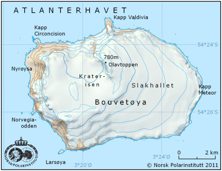
People often think of Bouvetøya as being part of Antarctica, but it lies north of 60°S and is therefore actually a sub-Antarctic island. Bouvetøya is tiny, a mere 49 km2, most of which is covered in ice. The island was formed from a volcanic crater, but the volcano has not erupted for ages. The highest point on the island is the edge of the old crater, Olavtoppen, 780 metres above sea level. It was the Frenchman Jean-Baptiste Charles Bouvet de Lozier who first discovered Bouvetøya in 1739, when led two French ships exploring for a better route to the Far East. There was thick fog, so Bouvet never went ashore on the land he believed to be a peninsula extending from “Terra Australis” – the unknown continent in the south. He named the point he had sighted “Cap de la Circoncision”. The geographical coordinates that were noted turned out to be incorrect and many years passed before the island was rediscovered. It was not until 1808 that English whalers caught sight of the island again, and the first landing was in 1822. That was when the island was named Bouvetøya, in honour of its discoverer. On 1 December 1927, members of the crew of the first Norvegia expedition went ashore on Bouvetøya and claimed the island for Norway. Bouvetøya is still usually enshrouded in mist or fog, just as it was in Bouvet’s time. Countless birds and animals live on Bouvetøya and both the island and the waters surrounding it were declared a nature preserve in 1972. The Norwegian Polar Institute sends expeditions to Bouvetøya regularly. In conjunction with a research expedition in 1979, three huts were established on the island. These huts were later lost. A new building (actually a container fitted out as a research station) was erected in 1996 for the use of researchers visiting the island. When a research team from the Norwegian Polar Institute arrived on Bouvetøya in late autumn of 2007, the patch of ground that had housed the research hut and a weather station had collapsed into the sea. The researchers had no choice but to set up a new camp elsewhere on the island. |
South Pole 1911–2011 is an informational outreach project run by the Norwegian Polar Institute
Contact person: