Did you know that Norwegian researchers lived in Antarctica from 1956 to 1960 – and that it had major political consequences?
In 1939, Norway annexed part of the Antarctic continent, Dronning Maud Land. In 1956, to ensure that this claim would be honoured, it was time to show Norwegian presence on the continent.
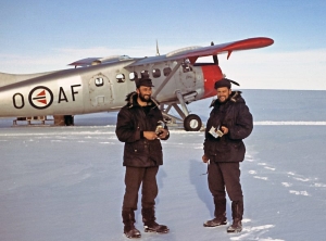
 Operation Penguin: Aerial photography in Dronning Maud Land. Photo: John Snuggerud / Norwegian Polar Institute
The Norwegian Antarctic expedition 1956–1960 was organised by Harald Ulrik Sverdrup, Director of the Norwegian Polar Institute. Over the three-year duration of the expedition, masses of new research data were gathered. The expedition also had major political implications, helping to ensure that Norway could play a leading role in the negotiations that resulted in the Antarctic Treaty, which was signed in December 1959.
The expedition base was placed on Märtha Kyst (Märtha Coast) in Dronning Maud Land, 35 km inland from the ice edge, and was named Norway Station. It was home to many as 14 team members and 42 Greenland huskies over the next few years. The expedition leader was Sigurd Helle. The participants worked in shifts to collect research data, and did not allow themselves many days off during their three-year sojourn.
In November 1957 a field party of four men, nine dogs and two tracked vehicles set off towards the mountains in the southeast. The vehicles were heavily loaded, pulling two or three sleds each, and the route they were taking led them through some dangerous stretches – Jutulstraumen, an ice stream full of crevasses. Their destination was solid ground – the mountains Fimbulheimen – where they intended to study ice and ice movements and do triangulation work, in order to secure the data needed to make maps of the area. Two hundred kilometres into the journey, disaster struck. One of their vehicles disappeared down a crevasse and the driver only barely managed to save himself. The rest of the journey had to be accomplished with only one vehicle. This was a major setback and it meant that the rest of the equipment had to be transported in several trips, but they reached the mountains eventually. Here they established a main depot and worked from their by dogsled. They did their studies and returned to the main station after five months without loss of life.
In the summer season of 1958–59, a team of 12 aviators from the Air Force (including three from the Norwegian Polar Institute) took aerial photographs of Dronning Maud Land. The oblique images were to be used for cartography of the area. In just a month, large segments were charted from the two Otter aircraft.